Visiting Alberta’s Past :
At the End of The Victoria Trail
by John Althouse
The eventful history of Alberta is a composition of many separate chapters. These chapters, while often separate and distinct, can also commonly overlap, ‘bleeding’ into one another. These periods may contain advances, sharp declines, and even the occasional period of stagnation, rot and decay. Nowhere have so many of these varied historic periods played out than in the locale known as the Victoria Settlement. This site, which may be unfamiliar to some of you, nestles anonymously almost forgotten along the north bank of the North Saskatchewan River about eight miles almost directly south of the Town of Smoky Lake.
This site enjoyed prominence over a wide span of the history of the territory that now is part of our province. It was long a seasonal encampment for the Cree who made this area home prior to the arrival of the Europeans. This nomadic people were able to not only survive but to thrive here. The area provided all the resources that they needed to live comfortably and contentedly.
In the early 1800s, the Europeans first arrived in the area as fur traders. One of the incarnations of Fort Edmonton, which had a tendency to relocate from time to time during the its early days, was located just six miles downstream at the month of White Earth Creek. This trait of relocating the fort could be problematic for those traveling to it by river especially if the packet detailing the move had not arrived prior to the departure of the travelers for the fort. This first flirtation with the fur trade in this area was a brief one as the fort soon returned up river and settled at a more permanent location.
Drawn by the fur trade, Métis people began to enter and settle in the area. When the land of Victoria Settlement was surveyed and divided into portions, it employed the river lot system in use in Quebec. In this system, the land extends far back from the river in long, narrow strips until it almost vanishes into the dark forbidding bush in the distance. This survey pattern is still readily visible when one travels along the trail today. One section along today’s Victoria Trail within the settlement is known as Métis Crossing. It is the site of a large cultural festival for the Métis people during each summer.
In 1862, Methodist missionaries George and John McDougall arrived in the area and set up a mission to administer to the First Nations population of the site. The mission eventually came to be known as Victoria Mission. The year 201 was the 150th anniversary of the founding of that mission. The following summer George McDougall brought his wife and seven younger children to the site. Here, the missionaries developed one of the first Protestant schools west of Manitoba. They also would develop a large hospital on the site. A smallpox epidemic raced across the Canadian prairies having a particularly devastating effect on the native population in 1870. Victoria did not escape its ravages, over a hundred Cree people were known to have died there, despite the best efforts of the Methodist missionaries. In fact, the entire McDougall family was stricken by the contagion. Mrs. McDougall, two of her daughters, Flora and Georgina, and their adopted First Nations sister Anna died from the disease. Today, if you take a short walk southward along a crude trail to the west of the settlement site, you will find their tombstones and gravesites within an iron fence near the river just a short distance from the mission where they spent their final years.
This tragic event was just one of the calamities that befell the First Nations people of the Canadian west for the next few years. In order to simply survive, these noble people signed a treaty and were removed to a reservation miles to the east of their traditional home area. This ended the need for a mission at Victoria. Gradually, the buildings were abandoned, or moved from the site. A black and white photograph captures the indignity of the mission hospital being hauled to Smoky Lake where it would serve as the basis of its new hospital.
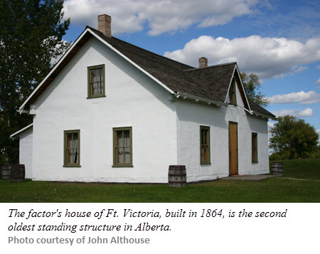
 As the mission declined, the fur trade re-established a presence in the area, right at the site. A new post named Fort Victoria was built there in 1864. The original fort consisted of a wood stake palisade and several buildings including a fairly substantial house for its factor. However, by this time, the fur trade in the area was already beginning to wane. Its life as a trading post would be relatively brief. When a post office was applied for in the area, the name Victoria was rejected by the Post Office Department as it was felt that there could be confusion with Victoria, BC. One June 1st, 1887, the site received its post office named Pakan after a Cree Chief who had played a prominent role in the area.
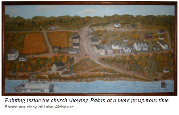
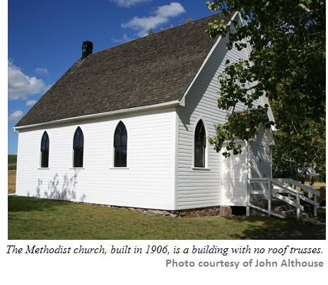
As the fur trade was phasing out, settlers began to enter the area. These settlers had been attracted by cheap homestead land which they might own and farm. Many of these farmers were Ukrainians from the Austro Hungarian Empire. A second Methodist church building was established at the site to administer to their needs in 1906. With the presence of farmers and craftsmen to serve their needs who moved to the site, Pakan became quite a busy agricultural service centre. At one point, it could proudly boast five farm implement shops. The settlement as also a hub of transportation as a ferry crossing the North Saskatchewan River for the major north-south route was at Pakan. The ferry remained in operation for many years. The future at Pakan indeed looked promising, prosperity was in the wind.
 However, nothing is ever certain. When the railway was laid through the area in the early 20th century, it did not pass through Pakan but eight miles to the north, where Smoky Lake would be established along the line and would become the pre-eminent settlement in the region. Pakan began its slide from prominence. The merchants gradually abandoned the earlier settlement either opting to relocate to Smoky Lake or simply going out of business. A bridge was built in the area in the 1970s. However, the new bridge crossed the river several miles upstream from Victoria Settlement. This was the final nail in the coffin of the settlement as it lapsed into obscurity and virtually vanished from the landscape.
Today, little remains to attest to the rich history of the site. As you drive eastward from the bridge along the Victoria Trail, you pass Métis Crossing. Further on you see the sign indicating the road leading uphill to the area cemetery. As you drive along the road, you can see the distinct patterns of the of the river lots. At the actual site, only two buildings remain: the factor’s house (1864) and the Methodist church (1906). Only the interpretive centre, role players, and a plaque on a stone cairn bear testament to the long and varied history of this site. Role playing interpreters will take you on a walk through time reacquainting you with Victoria Settlement’s rich and varied history.
On the western edge of the actual site that today is the Victoria Settlement Provincial Historic Site, looking north, you will see a hedge. This hedge once defined the limits of the local school yard. If you  look south, you will see the trail that you can walk to the McDougall graves. Make that walk and stand for a moment and reflect upon all the impermanence of all things. Sometimes, only the records that we keep and manage are all that remain to attest to the rich, vibrant, and varied past. This is the work that genealogists, family historians, and local historians do so very well.
It is this dedicated group that keeps the past alive and vibrant for those yet to come. They are our chroniclers who keep vibrant stories and the legacy of our past.
Originally appeared in Relatively Speaking, v.41 #2 (May 2013). Download it, now ›
